In Nigeria’s rich and varied geology, the occurrence of alluvial gold remains a compelling field for exploration and discovery. One recent field exercise sheds light on the importance of terrain, river morphology and systematic sampling for locating gold-bearing deposits. In this article we focus on the terrain characteristics in a drainage basin, the role of the river tributaries, and the significance of structural control in the context of alluvial gold in Nigeria.
The Terrain and Its Influence
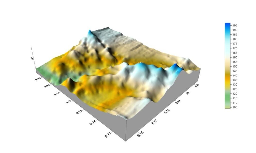
Terrain understanding is foundational when exploring for gold: it helps with exercise planning, predicts outcomes and forecasts duration. In the case‐study area (within the Bida Basin), the terrain is described as “several hills with steep and gentle slopes and the rivers appear to be structurally controlled.”
Hills and slopes matter. Steeper slopes tend to channel runoff more quickly, concentrate sediments, and may provide pathways for mineralized material to be transported downstream. On gentler slopes, sediments may deposit earlier or more diffusely, forming potential traps for heavier minerals such as gold. The juxtaposition of hills and sloping terrain in the basin means you have sources, transport pathways and deposition zones all interacting.
When rivers are structurally controlled meaning their course is impacted by underlying geology (faults, shear zones, fractures) the transport and deposition of gold-bearing sediments is influenced. Structural control can produce zones of reduced flow velocity (inside bends, terraces, benches) where gold may accumulate more readily.
In Nigeria, much of the gold occurs within the Basement Complex and related schist belts. For example, studies show that alluvial gold grains in the Rafin Gora drainage system (in north-western Nigeria) have morphologies that indicate they come from a proximal primary source, owing to the terrain and transport features. journalcps.com+1
Thus, understanding the combination of hills, slopes and structurally-driven drainage is key to mapping where alluvial gold might concentrate.
River Tributaries & Alluvial Gold Deposition
In the exercise described, alluvial gold was found along a river tributary after systematic and consistent panning and sampling. This underscores the importance of river tributaries in the gold pathway. When primary gold deposits (often quartz-vein hosted) weather and erode, particles are freed, transported by water and eventually settle in the fluvial system.
The tributary in question acts as a conveyor from the hinterland (hills, slopes) into depositional zones. The structural control of the river means that the tributary may follow fractures or shear zones: these are natural routes along which gold-bearing material and other associated minerals migrate.
In Nigeria specifically, up to 90 % of gold production has been reported to derive from alluvial deposits, i.e., from erosion of primary deposits and redeposition in streams and rivers. The key is: the heavier gold particles will drop out of suspension when the water energy drops, for example when a river widens, slows, bends or enters a terrace zone. Recognizing these morphological features streamside can greatly aid prospecting.
Systematic Panning, Sampling & Findings
The fieldwork described involved “systematic and consistent panning and sampling,” which is precisely the kind of disciplined approach required for alluvial gold exploration. Unlike spot panning, which may luck into gold, systematic sampling ensures representative coverage, better statistical confidence and more reliable outcome predictions.
In the described terrain, after this approach, alluvial gold was found. This confirms that the hills and structurally controlled drainage were indeed contributing to gold transport and deposition. The detection of ancillary trace elements in this case barium (Ba) and lithium (Li) on elevated areas adds further nuance: these may be indicators of basement rock alteration or associated mineralized systems which can feed gold into the system.
For instance, research in Nigeria shows gold grains with varying morphology and surface textures in stream sediments suggesting proximate sources and relatively short transport pathways. Thus the fact that elevated zones showed Ba and Li traces may hint at upstream bedrock mineralization feeding the alluvial system.
Terrain–Drainage–Deposition: Putting It All Together
Let’s summarize how the terrain and drainage interplay affects alluvial gold occurrence:
- Source zones: Hills, schist belts, shear zones in the basement complex host primary mineralization. Weathering over time liberates gold particles.
- Transport pathways: Steep slopes and structurally controlled rivers/tracks carry the weathered material into tributaries and main drains.
- Deposition zones: Where slope decreases, river energy drops, inside bends, terraces form, and sediments concentrate heavy gold particles settle.
In the sample exercise, all these elements appear to align: hills → tributary → sampling site yielded alluvial gold. The structural control of the rivers suggests a more predictable pathway for gold transport and hence easier targeting of sampling zones.
Why Terrain Understanding Matters in Planning & Forecasting
Proper terrain analysis has multiple benefits:
- Efficient Planning: Knowing which hill slopes are steep vs gentle, where tributaries run, where inside bends or terraces are allows expedition teams to prioritize sample locations, reducing wasted effort.
- Predictive Outcomes: Recognizing structural controls, slope changes, sediment traps enables prediction of where gold may accumulate rather than random sampling.
- Forecasting Duration: If the terrain is complex (steep slopes, thick overburden, difficult access), the time required and logistics will differ compared to gentler terrain. By understanding the terrain up front, one can estimate resource and time needs more accurately.
- Risk Mitigation: Terrain analysis helps anticipate challenges, for example flooding risk in river trenches, inaccessible slopes, thick sediment cover. In Nigeria, studies show that flooding may impact alluvial gold mining sites in river basins. RSIS International
Therefore, taking the time up front to survey terrain, map slopes, understand drainage morphology, and overlay structural geology pays dividends in an alluvial gold exploration project.
Nigerian Context: Why Alluvial Gold Is Promising
Within Nigeria, the alluvial gold potential is noteworthy. Sources point out that the country’s gold is found in primary and alluvial/elluvial forms within the basement complex and schist belts. For example, in the southwestern belt (the Ilesha‑Egbe Gold Field), research shows that alluvial material forms richer, more widely spread deposits that are derived from the weathering of primary gold-bearing rocks.
The statistic that around 90 % of Nigeria’s gold production comes from alluvial deposits highlights how important this form is in the national context. RSIS International For explorers working within Nigeria, focusing on alluvial systems can be more immediately rewarding (though primary sources obviously remain of interest).
Applying These Insights to Your Basin
Given the overview, here’s how you might apply the findings to the basin you’re working in:
- Map the hills & slopes: Identify steep vs gentle slopes, especially in the hills you noted. Gather elevation profiles, slope orientation and aspect. Steep slopes may supply material rapidly, gentler slopes may provide longer‐term deposition.
- Structural geology overlay: Look for lineaments, shear zones, fractures in the bedrock which could control drainage patterns and gold transport. Your observation that the rivers appear structurally controlled is a strong indicator.
- Drainage mapping: Map the river network and tributaries, locate inside bends, terraces, benches, points where slope drops, or where tributaries merge. These are key spots for accumulation of heavy minerals.
- Sediment sampling: Conduct systematic panning and sampling along the tributary and into the main drains. Use consistent intervals, replicate samples, record GPS location, sediment type, slope, water flow, sediment thickness.
- Trace element / indicator analysis: Since Ba and Li were detected on elevated areas, consider running geochemical assays on sediments for these and other indicator elements. They may reflect upstream alteration or bedrock sources.
- Recording logistics & forecast time: Use terrain data (slope, access, vegetation, sediment thickness) to estimate how long sampling and mobilization will take, what equipment is needed (pans, sieves, sample sacks, GPS, safety gear), and what costs may be involved.
Key Takeaways
- Terrain is not just backdrop: hills, slopes, drainage patterns and structural controls define how gold moves from source to sink.
- Alluvial gold in Nigeria is predominantly derived from basement‐complex mineralization and transported into placers and river sediments. earthsciencesmalaysia.com
- Systematic sampling along structurally controlled river tributaries in favorable terrain (hills + slopes + deposition zones) increases success likelihood.
- Geochemical indicators (e.g., Ba, Li) on elevated zones may hint at upstream mineralization feeding the alluvial system.
- Forecasting duration and planning logistics are much improved when terrain is properly understood ahead of fieldwork.
For further reading and deeper geological context, you may wish to explore:
- Omang B. O. et al., “Microchemical characterization and stream sediment composition of alluvial gold particles …” (Kushaka Schist Belt, NW Nigeria).
- Haruna M. Grema, “Geology, mineralogy and provenance of alluvial gold mineralization in River Gagare drainage basin…” (Wonaka Schist Belt, NW Nigeria).
- “Gold mining; a huge untapped opportunity” – a policy/industry overview of Nigeria’s gold potential via Nairametrics
- Global Homes Magazine: “Nigeria states with gold mining opportunities” – breakdown by state and type of mineralisation. globalhomesmagazine.com
At Eartho-Bi, we provide you with expert analysis in the best way possible.